Do I need a Level 2 Home Survey or a Level 3 Building Survey in Market Harborough?
The type of survey you require depends entirely on the age, size, and general condition of the property you are purchasing. Use the comparison below to determine which RICS inspection is right for your transaction:
Inspection Detail | RICS Level 2 Home Survey (formerly HomeBuyer Report) | RICS Level 3 Home Survey (formerly Full Structural Survey) |
|---|---|---|
Inspection Best Suited For | RICS Level 2 Home Survey Conventional, modern properties (built post-1990) of standard construction. | RICS Level 3 Home Survey Older, historic, or large properties, or those of non-standard construction. |
Inspection Property Condition | RICS Level 2 Home Survey Homes appearing to be in a reasonable, well-maintained state. | RICS Level 3 Home Survey Homes that are noticeably dilapidated or have been extensively altered. |
Inspection Depth of Inspection | RICS Level 2 Home Survey Surface-level visual inspection of accessible areas to highlight major faults. | RICS Level 3 Home Survey In-depth analysis of the property's structure, fabric, and integrity. |
Inspection Future Plans | RICS Level 2 Home Survey Buyers looking for a general overview before moving in. | RICS Level 3 Home Survey Buyers planning significant structural renovations or extensions. |
Inspection Advice Provided | RICS Level 2 Home Survey Highlights urgent defects that may affect the property's value. | RICS Level 3 Home Survey Detailed advice on defects, repair options, and ongoing maintenance consequences. |
Local Property Characteristics in Market Harborough
Properties built in this area have certain standard characteristics which dictate what type of survey you'll need for your property. Here is a table of different factors that could affect your property and require further investigation by your RICS surveyor:
Characteristic/Risk | Details |
|---|---|
Japanese Knotweed Risk: | Check the Environet heatmap to confirm. Source: Environment Agency & Environet UK Heatmap Data |
Listed Buildings: (Such as Grade I, Grade II*, and Grade II in Market Harborough) | There are circa 1 to 20 listed buildings in the local area. Note: Estimated based on the location's common property types and proximity from the data at Historic England. Your actual property may have a different characteristic or risk. Source: Historic England |
Ground Stability: Flags a risk for subsidence. | This area is generally considered low risk for ground stability issues. Source: The British Geological Survey (BGS) |
Market Harborough Specific Property Info |
|
Expert Tip: Review Unapproved Extensions and Alterations
Many homes in Market Harborough have undergone undocumented extensions, loft conversions, or structural alterations over the years which may lack proper building control sign-off.
Your RICS surveyor will highlight any structural irregularities or removed chimney breasts, and your conveyancer will request the necessary completion certificates from the local authority.
Izuka Francis-Soligbo AssocRICS
RICS Associate, RICS Registered Valuer
Local Building Surveyor in and around Market Harborough
Our Building Surveyors specialise in the local area and have completed house surveys in Corby, Billesdon, Wigston, Kettering, and Leicester. We also service the wider area of Leicestershire, and throughout England & Wales.
We work with specialist RICS Building Surveyors to undertake Home Buyers Surveys in Market Harborough. Whether you are buying an old run-down 'doer-upper' or standard construction freehold house, our RICS surveyors have seen them all. With a vast number of years of experience completing building surveys on properties in Market Harborough, we'll be able to give you the detailed Market Harborough HomeBuyers report that you will need to know and what defects there are with your property.
Defects flagged in a Market Harborough Home Buyers Survey

Local Tip: Subsidence
A Local Authority Search provides information about local planning charges, among other matters, which might affect your enjoyment of a property you're thinking of buying. A recent one bought for a property in Shepherd's Reach, Scraptoft LE7 9XQ revealed not only that the property was situated in an area defined as 'an area of special control for the display of advertisements but more recently that various planning applications had been lodged and approvals granted for the siting and building of 178 new houses with all the associated services required for this.

Local Tip: Damp
Some parts of Market Harborough are in areas where there is an elevated radon potential, with the highest being 3-5% above the action level. Streets such as Middledale Road and Stablegate Way are in this area. The Environmental Search provides details about the presence of radon in the area where a property you're looking to buy. Radon is a poisonous gas that can cause lung cancer and if the probability of finding it in an area is much higher than average, you are advised to carry out further investigations and your lender might insist up on it.

Local Tip: Asbestos
Noise pollution from roads in and around Market Harborough's area is most pronounced in dwellings in close proximity to the paths of the A6 and the A304, particularly affecting streets between the two roads, such as Fernfield Crescent and Meadowvale Road.
Noise pollution from railways is most raised along the path of the route passing through Market Harborough Station and is likely to be more of a factor in dwellings in close proximity to the tracks including for properties in streets such as Bellfields Lane and Braybrooke Road.
Why Choose SAM Conveyancing for your Home Survey?
In helping over 15,339 survey clients since 2014, we've learned a lot about surveys in Market Harborough using our panel of over 100 Royal Institution of Chartered Surveyors (RICS). Your Market Harborough surveyor will be local to your property, so whether you're worried about subsidence, damp, infestations, extensions, or even just for peace of mind, we've got you covered.
Our HomeBuyers Survey costs are fixed and competitive, as you'll see from all our Excellent reviews on Trustpilot. This means you don't have to break the bank to get a full health check on your new home. Get a Home Buyer Survey Quote today, or if you're not sure which survey to choose and want to know the difference between a Level 2 Home Survey and a Level 3 Building Survey, then give us a cal,l and we'll happily tell you what you need - 0333 344 3234 (local call charges apply).
What defects are flagged in a Homebuyer's Survey?

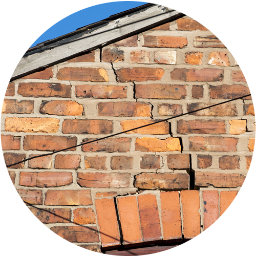
Cracks are inspected and in the report will confirm if you need a structural engineer as there are signs of historical or current movement.
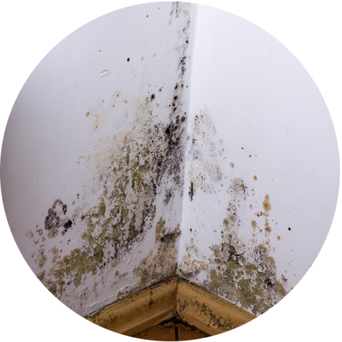
The RICS surveyor will use a moisture meter in the rooms and report any high levels along with any mould or damp causing damage to the walls/windows.
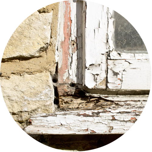
The wooden door frames and windows will be inspected for rotting and wood worm.

The surveyor looks for signs of infestations through droppings, damage to piping/flooring and in some cases finding where the nest is.

The surveyor will check the grounds of the property and, where possible, check over the fences to neighbouring plots to identify if there is a risk of Japanese knotweed.
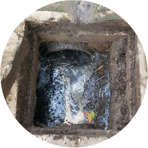
The surveyor lifts up accessible man hole covers to check if the drains are blocked. You may need to get your drains inspected with CCTV.
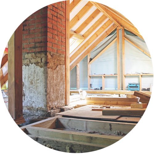
The surveyor will enter into the roof/loft space if there is a safe and accessible ladder. They'll look for insulation, signs of leaking and and damage.
Download an Example Level 2 and Level 3 Home Survey
Property Survey FAQs for Market Harborough

- online checklists
- videos
- free downloads
- useful tips
RICS Level 2 Home Survey with a Valuation
A RICS Level 2 Home Survey, which used to be called the HomeBuyer Report or a Home Buyer Survey, is generally suitable for:
- Bungalows
- Flats
- Standard construction houses
The majority of Market Harborough's leasehold flats require only a RICS HomeBuyer Report but for any Victorian conversions, a Building Survey may well be required.
RICS Level 3 Building Survey
A Level 3 Home Survey, also known as a Building Survey or a full structural, is the most comprehensive visual inspection a RICS surveyor can provide on a property in Market Harborough. It is suitable for:
- complex buildings, for example those that have been extensively extended and altered
- unique or older historic properties
- properties in poor condition; or
- those where the client is planning to carry out extensive repair and refurbishment work.
Speak to one of our team on 0333 344 3234 to find out if your property suits a RICS Building Survey, or read our article Which Home Buyers Survey suits your property .